 |
 |
 |
 |
| Figure 1.Hoko River Site in Washington State (Northwestern U.S.A.) | Figure 2.Site location on the Strait of Juan de Fuca | Figure 3.River mouth setting of the rockshelter | Figure 4.Site indicated by 5 meter scale (far right of picture) |
Dale R. Croes, Director, Hoko River Project
Washington State University
South Puget Sound Community College
Acknowledgements:
The Makah Tribal Nation
and Washington State University co-sponsor
the Hoko River project, which was made possible through support from the
M.J. Murdock Charitable Trust, the National Endowment for the Humanities,
the Washington State Office of Archaeology and Historic Preservation, US
West, and Ray and Jean Auel. Numerous researchers, Makah community members,
field personnel, and students contributed to the project's data recovery,
analysis, and reporting. The first and second volume of
the The Hoko River Archaeological Site Complex, reporting the overall
work is available through the Washington
State University Press (1-800-354-7360), entitled The
Hoko River Archaeological Site Complex, the Wet/Dry Site (45CA213),
3,000 - 1,700 B.P. (1996) and The Rockshelter (45CA21), 1,000 - 100 B.P.
This digital excavation of the Hoko River Rockshelter is supported through a foundation grant from South Puget Sound Community College (SPSCC), and the work of anthropology students gaining credit to program and produce this program: Matt Barclay and Audin Malmin. An Evergreen State College student, Mary Wright-Croes, has also helped build the program as a project for her classes. The SPSCC library was provided space and considerable assistance with the equipment, through the help of Russell Rose, Librarian, and Steve Whalen, Electronic Media Producer, Library Media. As an Anthropology faculty member at SPSCC, I thank them for making this digital computerization possible.
Introduction and Project Summary
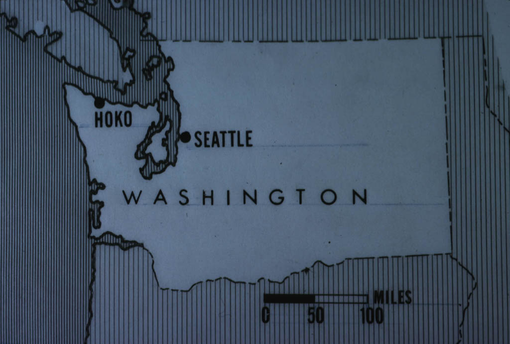
In the 1980's I directed excavation of a rockshelter archaeological site at the mouth of the Hoko River, Olympic Peninsula, Washington (Figures 1-4).
|
|
|
|
| Figure 1.Hoko River Site in Washington State (Northwestern U.S.A.) | Figure 2.Site location on the Strait of Juan de Fuca | Figure 3.River mouth setting of the rockshelter | Figure 4.Site indicated by 5 meter scale (far right of picture) |
The Hoko Rockshelter site proved to be particularly significant since:
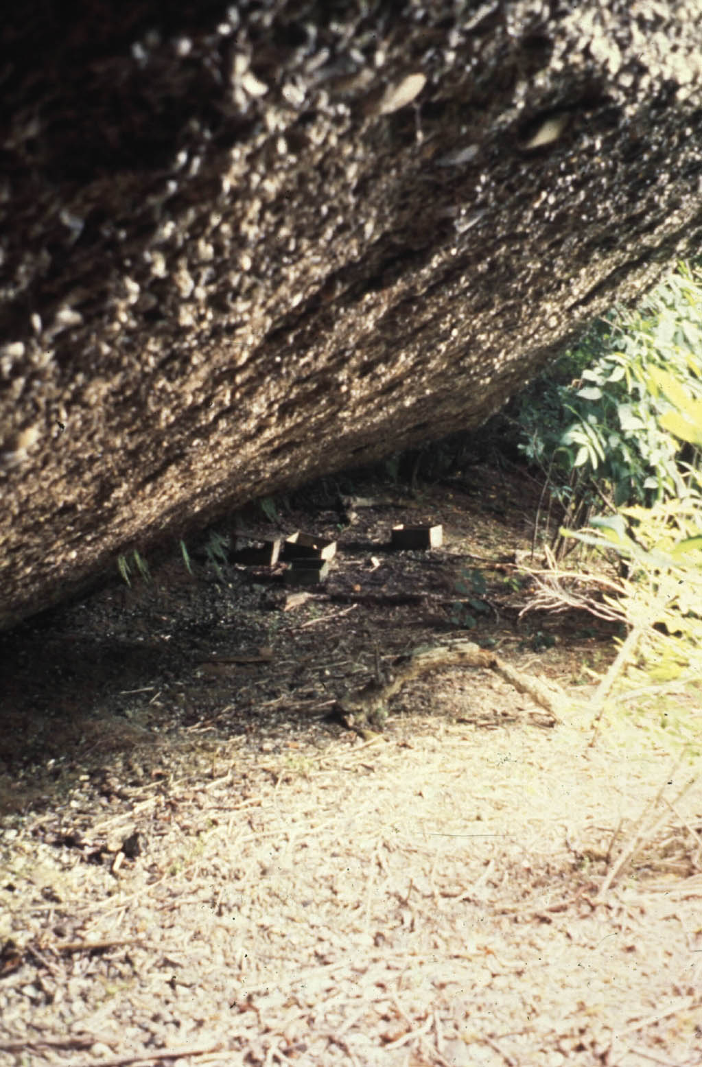
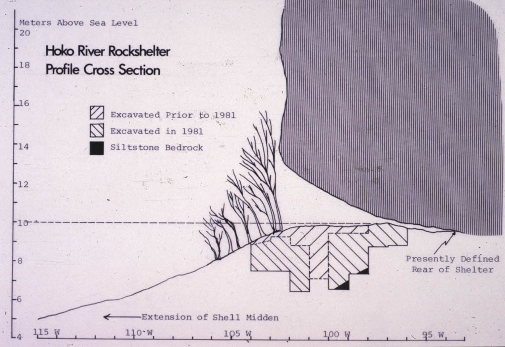
(1)it represents the only rockshelter habitation site of its size ever discovered on the Northwest Coast of North America (Figures 5-7),
 |
 |
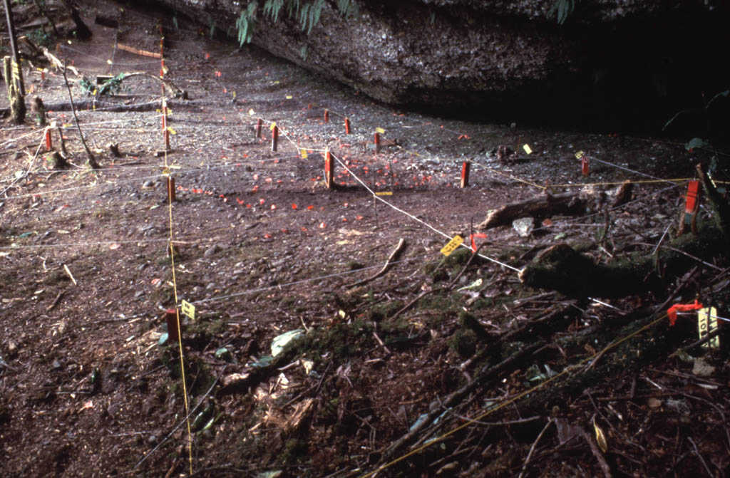 |
| Figure 5.Site as originally found (with stored dynamite boxes--removed!) | Figure 6.Cross-section of rockshelter | Figure 7.Surface with grid for excavation |
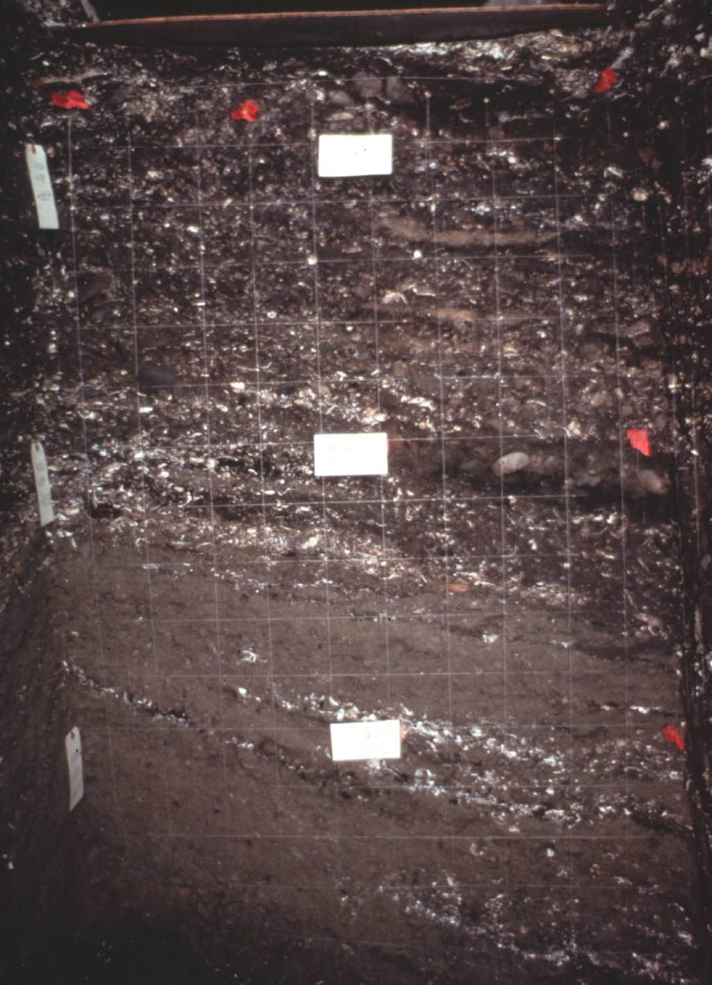
(2)it provides a record of up to 3.3 m of undisturbed shell midden buildup,
representing at least 1,000 years (Figures 9-12),
and
 |
 |
 |
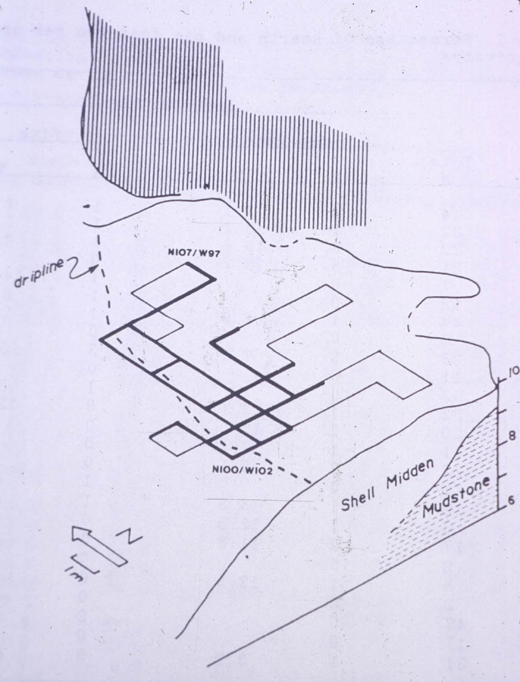 |
| Figure 9.Front-to-back stratigraphy. Note 12 meters of depth and "stacking" of hearth areas in interior. | Figure 10.Close-up of stratigraphy drawings (note hearth areas) | Figure 11.Plan view of excavation squares. Continuous walls were maintained for stratigraphy. | Figure 12.3-dimensional view of grid excavation areas. |
(3)1,342 layers of cultural deposits have been recorded with excellent preservation of faunal remains, shell/bone and stone artifacts, fire hearths, post molds, shell heaps and other features, all preserved in the well-defined boundaries of a natural rockshelter "container" (Figures 13-14).
 |
 |
| Figure 13. Great preservation of whole shell in deep-interior areas. | Figure 14.Trench excavation into the deep-interior shell midden |
Recognizing the importance of the site we decided to photograph in color slides and black & white film each 1 m x 1 m x 5 cm excavation surface (with 905 excavation surfaces recorded) at a set vertical distance. We knew this would be valuable data, but the only way to view and "re-excavate" the site photographically would be to either set up a whole panel of slide projectors or cut and paste a huge amount of printed black & white pictures (Figure 16). However today we do have the technology to scan these color images onto a CD Rom disk so the site can be easily explored and "re-excavated" by students. In fact this would provide a wonderful means to better exam the whole archaeological site both vertically and horizontally (Figure 17). For example, stored caches of harpoon points, left by prehistoric peoples, could be examined close up and in their entire context; something impossible while you are digging 1x1 meter squares, one at a time.
 |  |
 |
 |
| Figure 15. | Figure 16. | Figure 17 | Figure 18 |
Fortunately we did have the foresight to have our site photographer systematically record every 1 x 1 M x 5 cm surface throughout the site during the 8 seasons of excavation of this rockshelter site. The slides are now carefully catalogued onto slide pages and are being easily scanned and catalogued into computer image files.
As a teaching aid, an anthropology/archaeology student would not need to spend several summers in the field to see the process of excavating a Northwest Coast shell midden. Since excavation is the most intriguing and exciting part of archaeological discovery, this system should allow the student to not only experience the process, but actually discover new information about the site, impossible to discover through the slow and limited view of surfaces while actually excavating.
With the majority of the time and cost in recording this data accomplished, the use of this technology makes the information readily available as a powerful new teaching and research devise (Figure 18). We look forward to making this data available for all students and researchers. We will continue to add and improve future versions. We will contact you as updates are made, or you may contact us at dcroes@spscc.ctc.edu if you want to purchase an updated version. If you would like to report a bug in the CD-ROM, please contact Matt Barclay <mbarclay@openfbo.com>
FIGURE CAPTIONS:
Figure 1.Hoko River Site in Washington State (Northwestern U.S.A.)
Figure 2.Site location on the Strait of Juan de Fuca
Figure 3.River mouth setting of the rockshelter
Figure 4.Site indicated by 5 meter scale (far right of picture)
Figure 5.Site as originally found (with stored dynamite boxes--removed!)
Figure 6.Cross-section of rockshelter
Figure 7.Surface with grid for excavation
Figure 8.Crew work off scaffolds to protect undisturbed surface
Figure 9.Front-to-back stratigraphy. Note 12 meters of depth and "stacking"
of hearth areas in interior.
Figure 10.Close-up of stratigraphy drawings (note hearth areas)
Figure 11.Plan view of excavation squares. Continuous walls were maintained
for stratigraphy.
Figure 12.3-dimensional view of grid excavation areas.
Figure 13. Great preservation of whole shell in deep-interior areas.
Figure 14.Trench excavation into the deep-interior shell midden
Figure 15.Stratigraphy drawing crew working at night after days' excavation.
Figure 16.Horizontal excavation of hearth in square KJ--see top levels
of this square in digital excavation.
Figure 17.Example of vertical stratigraphy photograph.
Figure 18.View from the Hoko Rockshelter Site.